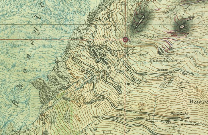
Fortress Maps: Secret Swiss Military Maps 1888–1952
New release (available May 16, 2016)
Martin Rickenbacher, “Fortress Maps: Secret Swiss Military Maps 1888–1952,” Murten; Cartographica Helvetica (52), 2016.
63 pages with 57 illustrations (some in color), A4 format, paperback, CHF 25.00, including shipping (not available through bookstores).
Table of Contents
Because the guns at the secret Swiss fortresses had no direct line of sight to the vast majority of potential targets, indirect firing methods were developed in which the geometric relationship between the gun and the target had to be determined using precise maps. From this, the so-called firing elements were calculated, which had to be adjusted at the gun when aiming in order to fire at a specific target. The Topographic Atlas of Switzerland at a scale of 1:50,000 (Siegfried Map) was not sufficient for this purpose. For the vast majority of the fortification maps, therefore, a scale of 1:10,000 was chosen.
Mapping of fortification areas began in 1891. Approximately 150 topographers were involved in the original surveys. They followed the surveying table method and incorporated terrestrial photogrammetry (image measurement). During World War I, thanks to the development of powerful data-processing equipment in the meantime, the “St. Gotthard Survey Detachment” was able to increase its mapping output many times over by using stereophotogrammetry.
In the run-up to World War II, the fourth major fortification map series was produced around Sargans. For about half a dozen so-called “border fortifications,” the foreign portion of the area to be mapped significantly outweighed the Swiss portion. In addition to existing foreign maps, aerial photographs taken by the Swiss Federal Topographic Service just a few weeks before the outbreak of war were used as a basis for these projects.
In the early 1950s, the Swiss Federal Topographic Service’s firing range map service was dissolved as a result of the so-called “Sparexpertise,” and the production of fortification maps—which at that time covered about 7.5% of the country’s territory—was discontinued. Thus, this specific phase of Swiss cartographic history had lasted about six and a half decades. The map material, classified as “secret” and of the highest quality, was not declassified until 2009.
Ordering address Cartographica Helvetica Publishing House Untere Längmatt 9, 3280 Murten Fax: 026 670 10 50 Email: [email protected] www.kartengeschichte.ch